
Two More Storms Could Bring Rain to Las Vegas This Week, Including Grand Prix Week
Related Stories
Rain and Wind Delay 665 Harry Reid Flights
Flood Control Limits Las Vegas Storm Damage
Grand Prix Glass Bottle Ban Starts Nov. 17
Two weather systems are lined up to bring rain chances to the Las Vegas Valley this week. The first arrives late Monday, Nov. 16, into Tuesday morning, and the second brings another chance of showers on Thursday, Nov. 19, right as Las Vegas Grand Prix race week heats up.
That matters because race week already means road closures near the Strip, and wet roads make every drive slower. The good news, as of the Sunday afternoon forecast, is that the weekend itself looks dry. Here is what each forecast says, how the two compare, and what to do now so a rainy weekday does not catch you off guard.
One important note before you read on: this is a forecast, not a promise. Desert storms can speed up, slow down, or fall apart. Check the latest forecast before you make plans that depend on the weather.

What Happened
FOX5 Las Vegas meteorologist Tiffany Olin laid out the week in a forecast published Nov. 12 and updated the morning of Nov. 13, under the headline "Wind and shower chances in Las Vegas Friday with two more storms next week." The forecast came after a windy, showery Friday, Nov. 13, with a Wind Advisory and gusts of 30 to 40 mph in the valley.
Here is how FOX5 described this week as of that Nov. 13 update:
Monday, Nov. 16: high of 66, with rain returning as a new storm system moves in.
Tuesday, Nov. 17: high of 60, with widespread rain possible as Monday's system lingers, and cool air.
Wednesday, Nov. 18: high of 61, mostly dry, with a slight chance of evening showers.
Thursday and Friday, Nov. 19 and 20: more shower chances as another system arrives. FOX5 said this one could affect the F1 races.
We re-checked the National Weather Service forecast for Las Vegas on Sunday afternoon, Nov. 15. The NWS forecast issued at 2:48 p.m. tells a similar story, with some changes in timing. It calls for a partly sunny Monday with a high near 70. Then scattered showers become likely after 10 p.m. Monday night, with a 50 percent chance of rain and gusts up to 23 mph. Showers stay possible before 10 a.m. Tuesday, with a 40 percent chance, before skies turn mostly sunny. Tuesday turns breezy, with south-southwest winds of 15 to 22 mph and gusts as high as 34 mph. The high Tuesday is near 66.
The NWS calls for a mostly sunny Wednesday with a high near 64. Thursday turns mostly cloudy with a chance of showers, mainly after 10 a.m., and a high near 62. The chance of showers continues Thursday night, with a low around 45. Then the NWS shows a sunny Friday, a sunny Saturday and a mostly sunny Sunday, with highs in the low 60s. The NWS forecast did not list any watches, warnings or advisories for Las Vegas when we checked.
What does a "50 percent chance" really mean? The National Weather Service uses that number to describe the chance that any given spot in the forecast area gets at least a small, measurable amount of rain during that time. It does not mean half the valley will get wet, and it does not mean it will rain half the time. In a valley as big as ours, one neighborhood can get a downpour while another a few miles away stays dry. That is why your street may not match the forecast exactly.
So the two forecasts agree on the big picture. Two systems bring rain chances, one early in the week and one around Thursday. The difference is in the details. The newer NWS forecast pushes Monday's rain later, into Monday night, and shows Friday and the weekend drying out.

Why It Matters to Las Vegas Residents
Rain in Las Vegas is not like rain in most cities. Our roads collect oil and rubber during long dry stretches. When the first rain hits, that layer turns slick fast. Drivers who are not used to wet roads tend to brake late and follow too close. That is why even a light shower can lead to a jump in crashes and slow commutes across the valley.
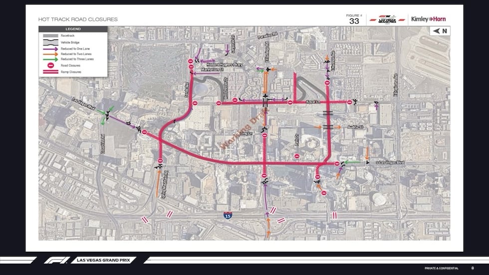
Now add Grand Prix week. Race week brings road closures, detours and extra traffic around the Strip and the resort corridor. Glass bottle rules also start Nov. 17, which we covered in Grand Prix Glass Bottle Ban Starts Nov. 17. If you work on or near the Strip, a wet Monday night or Thursday on top of closures could make your drive a lot longer than normal. Leave extra time.
Wind is part of this too. The NWS forecast calls for gusts up to 34 mph on Tuesday. Wind like that can knock over trash cans, blow patio furniture around and bring down weak tree limbs. If you have loose items in your yard or on your balcony, Monday is a good day to put them away.
For homeowners, the storms are a reminder to look at your home's drainage. The valley has already seen heavy rain this fall. If your yard puddled, your roof leaked, or water pooled near your foundation during the last storms, this week gives you a chance to see whether a quick fix worked. Many small water problems in desert homes come from clogged gutters, blocked yard drains, or soil that slopes toward the house instead of away from it.
Renters should pay attention too. If you notice a leak, take a photo and report it to your landlord or property manager in writing right away. Small leaks turn into big repairs when they are left alone, and having a record helps everyone.
Pet owners should plan ahead too. Many dogs get nervous when wind picks up or thunder rolls through. Bring pets inside Monday night and Tuesday morning, and make sure gates are latched so a scared dog cannot slip out. Wet, windy nights are when shelters often see more lost pets.
Parents may want a backup plan for the school run. Rain slows drop-off lines, crosswalks get crowded, and kids walking to school get soaked fast. A light rain jacket in the backpack Tuesday and Thursday is an easy fix.
Background and History
This fall has been wetter than usual in Southern Nevada. Storms around Halloween and the start of November brought heavy rain to the valley. We looked at how the flood control system handled those storms in Flood Control Limits Las Vegas Storm Damage. Those same storms also slowed travel, as we covered in Rain and Wind Delay 665 Harry Reid Flights.
The rain has had an upside. Lake Mead, the source of most of Southern Nevada's water, rose more than 2 feet after the late-October floods, according to the Las Vegas Review-Journal. One wet season will not fix the long drought on the Colorado River, but every bit of runoff helps.
The Clark County Regional Flood Control District has spent decades building detention basins and channels across the valley. Those basins catch storm water and release it slowly so streets do not flood as badly as they used to. You have probably driven past one without noticing. Many look like empty dirt fields or parks for most of the year, then fill with water during a big storm.
Even with that system, low spots and washes can still flood fast. Water can rise within minutes, and moving water only a few inches deep can knock a person down or push a car off the road. That is why local agencies repeat the same message every storm season: if a road is covered with water, turn around.

What Happens Next
The first system is the one to watch for Monday night and Tuesday morning. Based on the NWS forecast, the most likely time for rain is after 10 p.m. Monday and before 10 a.m. Tuesday. That puts the Tuesday morning commute at the most risk. If you drive early on Tuesday, plan for wet roads, slower traffic and gusty wind.
Wednesday looks like a break, with mostly sunny skies. Then the second system brings a chance of showers Thursday, mainly after 10 a.m., and into Thursday night. FOX5's earlier forecast also kept shower chances in place for Friday. The newer NWS forecast shows Friday turning sunny. Which one is right will depend on how fast that second system moves through.
The Las Vegas Grand Prix race is Saturday night, Nov. 21. As of the Sunday afternoon NWS forecast, Saturday looks sunny with a high near 61 and a low around 42 that night. That is cool for Las Vegas, so anyone heading to a watch party or working outside that night should dress in layers. Forecasts can change a lot over six days, so keep checking.
Cooler air is the other part of this story. After highs near 70 on Monday, the NWS forecast drops daytime highs into the low 60s for the rest of the week, with overnight lows in the low 40s by Tuesday night and Friday night. That is the first real taste of winter for many locals. If you have not tested your furnace yet this season, this is a good week to do it. Replace the air filter, run the heat for a few minutes, and listen for odd noises. It is better to find a problem on a mild afternoon than on the first cold night.
After the race, the forecast settles into dry, cool weather into next week, with highs in the low 60s. That is normal for late November in the desert.
Ryan's Take
I talk to a lot of buyers who move here from places where it rains all the time. They are often surprised that a half inch of rain can cause so many problems in Las Vegas. The truth is, our homes and roads are built for dry weather. That is why I tell every buyer to pay attention to drainage during a home tour. Look at where the yard slopes. Look for water stains on ceilings and around windows. Ask the seller about any leaks or roof repairs. A storm week like this one is actually a great time to look at a home, because you can see how it handles water.
For sellers, rain is a chance to catch problems before a buyer's inspector does. If you plan to list this winter or spring, walk your home during or right after a storm. Check the attic if you can do it safely. Look for damp spots in the garage and along the base of walls. Fixing a small leak now is much cheaper than giving a big credit later. A dry, well-kept home also photographs better and gives buyers one less thing to worry about.
One more thing I see often: many Las Vegas homes have concrete tile roofs. The tiles themselves can last a long time, but the layer underneath them, called the underlayment, wears out with years of sun and heat. When that layer fails, a roof can look fine from the street and still leak in a storm. If your home is older and you have never had the roof checked, a roofer can tell you where it stands. Buyers should ask about the roof's age and any past repairs, and get it looked at during the inspection period. It is one of the most common surprises I see in older homes in the valley.

What You Can Do
Check the forecast often. The National Weather Service office in Las Vegas updates its forecast several times a day. Local TV stations, including FOX5, also post updates. Look again Monday afternoon before the first system arrives, and again Wednesday before the second.
Prep your yard Monday. Put away loose patio cushions, umbrellas and decorations before Tuesday's wind. Make sure trash and recycling bins are secured. Clear leaves out of gutters and yard drains if you can do it safely.
Plan your commute. If you drive Tuesday morning or Thursday, leave early. Turn on your headlights when it rains. Slow down, leave more space, and never drive into a flooded road or wash. If you work near the Strip, look up race-week road closures before you leave.
Watch your home. During and after the rain, look for leaks, damp spots and pooling water near your foundation. Take photos and write down what you see. That record helps if you need a repair, an insurance claim, or a disclosure when you sell.
Know who to call. If you see a flooded street, a downed tree blocking a road, or a clogged storm drain, report it to your city or to Clark County if you live in an unincorporated area. In an emergency, call 911. Do not try to clear storm drains in moving water.
Dress for a cool race weekend. If you plan to watch the Grand Prix at a local watch party Saturday night, bring a jacket. A low around 42 feels cold when you are standing outside for hours.
Have questions about how this affects your home or neighborhood? Reach out to Ryan Rose or text/call 702-747-5921 anytime. Ryan Rose | Real Broker, LLC | 702-747-5921 | ryan@rosehomeslv.com | rosehomeslv.com
Sources
National Weather Service, Las Vegas: 7-day forecast for Las Vegas, issued Nov. 15, 2026, 2:48 p.m.
Categories
- All Blogs (4867)
- Absentee Owner (1)
- Affordability (3)
- ALIANTE (53)
- Anthem (27)
- Ascension (49)
- Assumable Loan (1)
- Astra (47)
- BLACK MOUNTAIN (47)
- Buyers (20)
- Cadence (16)
- Calico Ridge (48)
- Canyon Fairways (50)
- CANYONS OF SUMMERLIN (48)
- CENTENNIAL HILLS (80)
- Comparisons (46)
- CROSSINGS IN SUMMERLIN (47)
- DESERT SHORES (47)
- Divorce (3)
- Downsizing (13)
- EAGLE HILLS (45)
- Empty Nester (1)
- Enterprise (1)
- EXPIRED LISTINGS (13)
- First Time Homebuyer (4)
- Green Valley (136)
- Henderson (70)
- HORIZONS EDGE (48)
- Housing Market Trends (98)
- Informative (101)
- Inspirada (53)
- Lake Las Vegas (2)
- Lakes Las Vegas (2)
- Las Vegas Real Estate (183)
- Local News (1078)
- Luxury (1)
- MacDonald Highlands (87)
- MacDonald Ranch (98)
- Madeira Canyon (93)
- MESQUITE NV (103)
- MOUNTAIN TRAILS (43)
- Mountains Edge (65)
- Naked City (35)
- New Construction (120)
- New Construction Las Vegas (20)
- North Las Vegas (24)
- Northgate (23)
- PALISADES SUMMERLIN (38)
- Probate (25)
- Providence (2)
- Quail Ridge (35)
- QUEENSRIDGE (53)
- Red Rock (1)
- RED ROCK COUNTRY CLUB (45)
- Relocating to Summerlin (197)
- Relocation (44)
- Retired (1)
- Retirement (1)
- Reverence (15)
- RHODES RANCH (49)
- Ridgebrook (30)
- Sellers (210)
- Seven Hills (77)
- Silverado Ranch (1)
- Silverstone Ranch (39)
- SKYE CANYON (100)
- SKYE CANYONE (4)
- Southern Highlands (78)
- Southwest (17)
- SPANISH TRAILS (47)
- SPRING VALLEY (60)
- Summerlin (101)
- Sun City Summerlin (3)
- The Arbors (36)
- The Cliffs (42)
- THE HILLS (44)
- THE PASEOS (52)
- The Pueblos (24)
- THE PUEBLOS OF SUMMERLIN (40)
- THE RIDGES (57)
- THE VISTAS OF SUMMERLIN (45)
- The Willows (59)
- Thoughts on Home Tour (2)
- TOURNAMENT HILLS (47)
- Veterans (3)
- WHITNEY RANCH (55)
- Workers Advantage Program (88)
Recent Posts


GET MORE INFORMATION